Columbia, SC, September 7, 2025
News Summary
Columbia, SC is under a severe weather alert as thunderstorms approach the area. With wind gusts anticipated to reach up to 60 mph and pea-sized hail expected, residents in Columbia, Irmo, and surrounding counties are urged to take precautions and seek shelter. The storms may lead to localized flooding and significant damage, with another storm system predicted for Monday. The weather forecast suggests continued rain throughout the week while temperatures hover around 90 degrees.
Severe Weather Warning for Columbia, SC
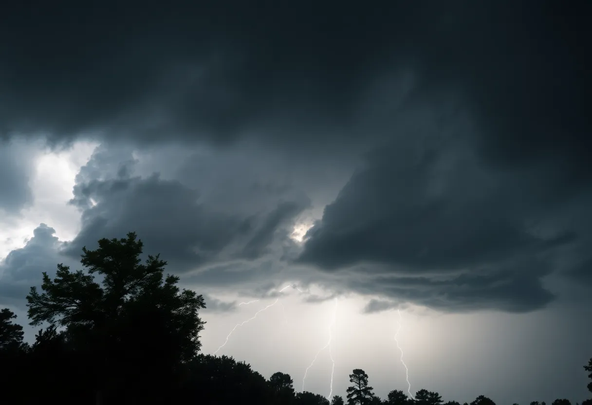
Columbia, SC, is bracing itself as severe thunderstorms make their way into the area. Just after 8 p.m. on Saturday, the National Weather Service in Columbia sounded the alarm, issuing a weather alert to prepare residents until 9 p.m. tonight. This alert covers a wide area including **Fairfield, Kershaw, and Richland counties**.
So what can residents expect? Well, brace yourselves for some strong winds! Predicted gusts could hit up to 50 mph, and don’t forget to keep an eye out for those pesky little hailstones, as pea-sized hail measuring a quarter of an inch may accompany the storm. Sounds like a wild evening ahead!
As the storm rolls in, Doppler radar has already detected a strong thunderstorm near **Irmo**, moving northeast at about 20 mph. Areas that are likely to be affected include **Columbia, Irmo, Winnsboro, Blythewood**, and more. **Major highways** like Interstate 26 between mile markers 96 and 102, and Interstate 77 between mile markers 24 and 36 could also see impacts from the storm. If you’re out and about, be ready for potentially gusty winds that might knock down tree limbs or blow around loose items—it’s not going to be a pleasant drive!
The National Weather Service has advised everyone to seek shelter indoors if you’re outside when the storm hits. There’s also a chance for torrential rainfall that could lead to localized flooding, so it’s best to stay away from flooded roadways. Let’s talk about the lightning—frequent cloud-to-ground strikes are happening, and remember, lightning can travel up to ten miles from the thunderstorm!
Fast forward to Sunday, and another storm system is expected. By around 10:40 a.m., a severe thunderstorm warning for **Columbia, Lexington, and West Columbia** will be in effect until approximately 11:15 a.m. This time, the winds could gust up to a whopping **60 mph** and more hail could be on the way. Over the previous night’s storms, the region already faced downed branches, trees, utility poles, tricky driving conditions, and a staggering **10,000 power outages** in the Midlands, so it’s going to be crucial to stay alert!
The forecast for Sunday and Monday shows more severe weather on the horizon. The greatest threat appears to be damaging winds, especially from late morning to mid-afternoon on Sunday, particularly affecting areas south of the Interstate 20 corridor. And if that wasn’t enough to keep folks on their toes, additional storms with the potential for tornadoes are expected on Monday, bringing the possibility of significant damage to trees, homes, and vehicles. It’s advisable to keep an eye on local updates!
By Monday night, we might see up to one inch of rain accumulating, and it looks like the rainy weather will linger throughout the week, with the exception of a brief respite on Wednesday. Temperatures in the region are expected to hover around **90 degrees** in the upcoming days, adding to the summer heat amid all this tumultuous weather.
FAQ Section
What areas are affected by the severe thunderstorm warnings?
The warnings cover Fairfield, Kershaw, and Richland counties, including places like Columbia, Irmo, and Winnsboro.
What should I do during the storm?
Seek shelter indoors and avoid driving on flooded roadways. Stay away from windows and do not use electrical appliances during the storm.
What kind of damage can these storms cause?
Potential damage includes downed tree limbs and power lines, localized flooding, and possibly significant harm to mobile homes and vehicles.
Is there any risk of tornadoes?
Yes, there is a risk of tornadoes, particularly on Monday, and it’s important to stay tuned to local weather updates for the latest information.
What should I expect weather-wise for the rest of the week?
Expect rainy conditions to continue throughout the week, with daytime temperatures around 90 degrees. However, a dry break is anticipated on Wednesday!
Key Features of the Weather Alert
| Feature | Details |
|---|---|
| Wind Gusts | Up to 60 mph expected |
| Hail | Pea-sized (0.25 inches) |
| Flood Risk | Localized flooding possible |
| Lightning | Frequent cloud-to-ground strikes |
| Rain Accumulation | Up to 1 inch by Monday night |
| Severe Weather Dates | Sunday and Monday |
Deeper Dive: News & Info About This Topic
HERE Resources
Air Quality Advisory Issued Across Upstate New York
Richland County Hosts Back-to-School Bashes This Summer
Severe Thunderstorm Warning Issued for Lexington and Richland Counties
Irmo Residents Urged to Steer Clear of Flooded Roads
Rowena Fire Rages in Columbia River Gorge
Winter Weather Hits South Carolina with Snow Flurries
Richland County Hosts Back-To-School Bashes Amid Severe Weather
Severe Thunderstorm Warning in South Carolina: Stay Safe!
Severe Thunderstorms Cause Widespread Damage in Columbia, SC
Lexington and Richland Counties Under Severe Thunderstorm Warning
Additional Resources
- WLTX: Weekend Weather Forecast
- Wikipedia: Severe Weather
- The State: Weather News
- Google Search: Weather Forecast
- WACH: Skywatch Weather Blog
- Google Scholar: Weather Alerts
- WIS TV: First Alert Weather Day
- Encyclopedia Britannica: Weather
- WLTX: Weather Alert – South Carolina
- Google News: Thunderstorms
Author: STAFF HERE IRMO
The IRMO STAFF WRITER represents the experienced team at HEREIrmo.com, your go-to source for actionable local news and information in Irmo, Lexington and Richland Counties, and beyond. Specializing in "news you can use," we cover essential topics like product reviews for personal and business needs, local business directories, politics, real estate trends, neighborhood insights, and state news affecting the area—with deep expertise drawn from years of dedicated reporting and strong community input, including local press releases and business updates. We deliver top reporting on high-value events such as the Irmo Okra Strut Festival, Harbison Community Events, and local sports tournaments at the Palmetto Health Credit Union Foundation Stadium. Our coverage extends to key organizations like the Irmo Chapin Recreation Commission and the Lexington Chamber and Visitors Center, plus leading businesses in retail and healthcare that power the local economy such as Village at Sandhill and Lexington Medical Center. As part of the broader HERE network, including HEREAiken.com, HEREBeaufort.com, HEREChapin.com, HERECharleston.com, HEREClinton.com, HEREColumbia.com, HEREGeorgetown.com, HEREGreenwood.com, HEREGreenville.com, HEREHiltonHead.com, HEREIrmo.com, HEREMyrtleBeach.com, HERENewberry.com, HERERockHill.com, and HERESpartanburg.com, we provide comprehensive, credible insights into South Carolina's dynamic landscape.